
Thank you for supporting this site ❤️
Make a donation
Make a donation
Seillans topographic map
Click on the map to display elevation.
Thank you for supporting this site ❤️
Make a donation
Make a donation
Seillans
Die ersten Siedlungen führen ins 5. Jahrhundert vor Christus zurück, als ein kleiner keltisch-ligurischer Stamm, die „Sayllens“, dort Verteidigungsanlagen auf der Anhöhe anlegten. Von der griechischen Besiedelung, die später in der Küstenregion stattfand, blieb dieses Oppidum unberührt.
Thank you for supporting this site ❤️
Make a donation
Make a donation
About this map
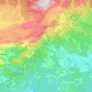
Name: Seillans topographic map, elevation, terrain.
Average elevation: 572 m
Minimum elevation: 141 m
Maximum elevation: 1,420 m
Thank you for supporting this site ❤️
Make a donation
Make a donation
Other topographic maps
Click on a map to view its topography, its elevation and its terrain.
Le Revest-les-Eaux
Frankreich > Provence-Alpes-Côte d'Azur > Var > Le Revest-les-Eaux > Le Revest-les-Eaux
Average elevation: 327 m