
Make a donation
Neukölln topographic map
Click on the map to display elevation.
Make a donation
Neukölln
Neukölln is on the North European Plain, which is typically characterized by low-lying marshy woodlands with a mainly flat topography. The quarter lies on the geological border between the shallow Weichselian Warsaw-Berlin Urstromtal glacial valley and the northernmost edge of the Teltow young drift ground moraine plateau, specifically the Rollberge, a small range of glacial hills rising to the south of Hermannplatz and the street Hasenheide, and to the west of Rixdorf and the street Karl-Marx-Straße. Neukölln's average natural elevation is 43.6 m (143 ft) above NHN, ranging from 32.3 m (106 ft) to 54.8 m (180 ft), with the highest man-made elevation at 67.9 m (223 ft) achieved by the Rixdorfer Höhe, a schuttberg in the Volkspark Hasenheide. Neukölln's geographical center, based on a minimum bounding plane, is located east of Richardstraße 101 near Kirchgasse at a linear distance of approximately 2.3 km (1.4 mi) to the river Spree with an elevation of 34.8 m (114 ft).
Make a donation
About this map
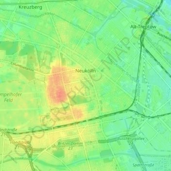
Name: Neukölln topographic map, elevation, terrain.
Location: Neukölln, Berlin, Germany (52.45876 13.40608 52.49587 13.47855)
Average elevation: 43 m
Minimum elevation: 27 m
Maximum elevation: 67 m
Make a donation
Other topographic maps
Click on a map to view its topography, its elevation and its terrain.
Teufelsberg
Teufelsberg was originally thought to be 115 metres (377 ft) high, which placed it at the same elevation as Großer Müggelberg (the summit of Müggelberge), and was the highest point in West Berlin. New measurements show that Teufelsberg is actually 120.1 metres (394 ft) high, making it higher than Großer…
Average elevation: 54 m
Viktoriapark
On the occasion of the elevation of the monument ideas appeared to lay out a park around it. Two years later the design of a park was put out to tender. Hermann Mächtig (*1837-1909*), since 1877 Berlin's city garden director, handed in a design, already using the name Victoria Park, in honour of Princess…
Average elevation: 45 m
Make a donation