
Thank you for supporting this site ❤️
Make a donation
Make a donation
Sadangmekar topographic map
Click on the map to display elevation.
Thank you for supporting this site ❤️
Make a donation
Make a donation
About this map
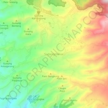
Name: Sadangmekar topographic map, elevation, terrain.
Location: Sadangmekar, West Bandung, West Java, Java, Indonesia (-6.80020 107.48156 -6.76020 107.52156)
Average elevation: 970 m
Minimum elevation: 756 m
Maximum elevation: 1,228 m
Thank you for supporting this site ❤️
Make a donation
Make a donation
Other topographic maps
Click on a map to view its topography, its elevation and its terrain.
DUSUN IV DESA MUKAPAYUNG KEC. CILILIN KAB. BANDUNG BARAT
Indonesia > West Java > West Bandung
Average elevation: 918 m
Thank you for supporting this site ❤️
Make a donation
Make a donation