
Thank you for supporting this site ❤️
Make a donation
Make a donation
Strahwalde topographic map
Click on the map to display elevation.
Thank you for supporting this site ❤️
Make a donation
Make a donation
About this map
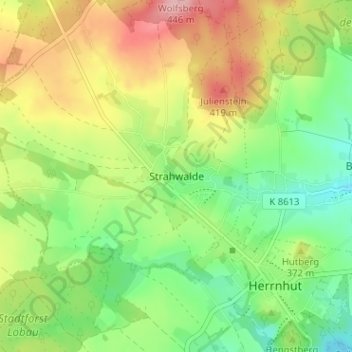
Name: Strahwalde topographic map, elevation, terrain.
Location: Strahwalde, Herrnhut, Görlitz, Sachsen, 02747, Deutschland (51.00903 14.70601 51.04903 14.74601)
Average elevation: 355 m
Minimum elevation: 292 m
Maximum elevation: 440 m
Thank you for supporting this site ❤️
Make a donation
Make a donation
Other topographic maps
Click on a map to view its topography, its elevation and its terrain.