
Schaffelberg topographic map
Interactive map
Click on the map to display elevation.
About this map
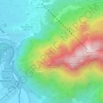
Name: Schaffelberg topographic map, elevation, terrain.
Average elevation: 1,095 m
Minimum elevation: 830 m
Maximum elevation: 1,662 m
Other topographic maps
Click on a map to view its topography, its elevation and its terrain.
Oberammergau
Duitsland > Beieren > Landkreis Garmisch-Partenkirchen > Oberammergau
Oberammergau, Landkreis Garmisch-Partenkirchen, Beieren, 82487, Duitsland
Average elevation: 1,064 m