
Thank you for supporting this site ❤️
Make a donation
Make a donation
Camisan topographic map
Click on the map to display elevation.
Thank you for supporting this site ❤️
Make a donation
Make a donation
About this map
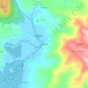
Name: Camisan topographic map, elevation, terrain.
Location: Camisan, Loboc, Bohol, Central Visayas, 6316, Philippines (9.61333 124.01333 9.65333 124.05333)
Average elevation: 101 m
Minimum elevation: -2 m
Maximum elevation: 361 m
Thank you for supporting this site ❤️
Make a donation
Make a donation
Other topographic maps
Click on a map to view its topography, its elevation and its terrain.