
Thank you for supporting this site ❤️
Make a donation
Make a donation
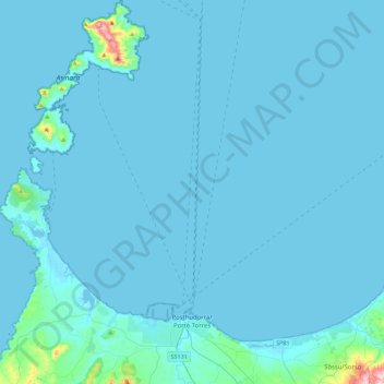
Posthudorra/Porto Torres topographic map
Click on the map to display elevation.
Thank you for supporting this site ❤️
Make a donation
Make a donation
Posthudorra/Porto Torres
The morphology of "city part" is flat; the area of Porto Torres and the rest of north-west Sardinia is characterized by a Nurra plain, with some hill formations in the middle of it. Part of this hill formation is in the municipality of Porto Torres, the highest elevation being Monte Alvaro, rising to a height of 342 m above sea level.
Thank you for supporting this site ❤️
Make a donation
Make a donation
About this map
Name: Posthudorra/Porto Torres topographic map, elevation, terrain.
Location: Posthudorra/Porto Torres, Sassari, Sardinia, 07046, Italy (40.78142 8.20876 41.12073 8.45885)
Average elevation: 15 m
Minimum elevation: -1 m
Maximum elevation: 418 m
Thank you for supporting this site ❤️
Make a donation
Make a donation
Other topographic maps
Click on a map to view its topography, its elevation and its terrain.