
Make a donation
Hamedan topographic map
Click on the map to display elevation.
Make a donation
About this map
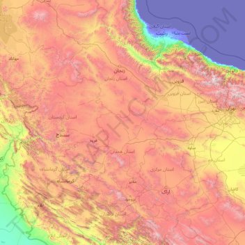
Name: Hamedan topographic map, elevation, terrain.
Location: Hamedan, Iran (32.83231 45.96651 38.03231 51.16651)
Average elevation: 1,465 m
Minimum elevation: -31 m
Maximum elevation: 4,553 m
Make a donation
Other topographic maps
Click on a map to view its topography, its elevation and its terrain.
Kermanshah
Kermanshah has a climate which is heavily influenced by the proximity of the Zagros mountains, classified as a hot-summer Mediterranean climate (Csa) bordering on a humid continental climate (Dsa). The city's altitude and exposed location relative to westerly winds makes precipitation a little bit high (more…
Average elevation: 1,416 m
Rafsanjan
Iran > Kerman Province > Rafsanjan County
Rafsanjan is located in south part of the Lut desert, in north-west of Kerman province. The longitude of this city is 56 degrees east and the latitude is 30 degrees south. The Average distance between Kerman and this city is 110 km (68 mi). The city has an airport and railway (Tehran-Bandar Abbas route).…
Average elevation: 1,539 m
Make a donation
Khorramabad
Iran > Lorestan Province > Khorramabad County
Khorramabad has mild and semi-humid Mediterranean climate with high amount of rainfall during spring and winter. It is the sixth cities in Iran having high level of annual rainfall. Khorramabad has what is classed under the Köppen climate classification as a Hot-summer Mediterranean climate (Csa) climate. Its…
Average elevation: 1,368 m
Make a donation
Shahin Shahr
Iran > Isfahan Province > Shahin Shahr and Meymeh County
The city is among the central mountain ranges of Iran to the east of the Zagros Mountains. It has an altitude of 1662 meters on average with a slope of 16%. It has a dry climate with very little precipitation. The variation in temperature is about 50 degrees Celsius.
Average elevation: 1,601 m
Make a donation
Make a donation
Make a donation
Amol
Iran > Mazandaran Province > Amol County
Amol is located on the banks of the Haraz River (26 25'N 52 21'E) at an altitude of 76 m above the sea. It is about 18 km from the Caspian Sea and about 10 km from the northern Alborz mountains. It is 180 km from the Iranian capital, Tehran, with a picturesque drive through Haraz Road. Sari, the capital of…
Average elevation: 87 m
Make a donation
Make a donation
Make a donation
Make a donation
Make a donation
Isfahan Province
With an elevation of 4,040 metres, the Shahankuh is the highest peak in Isfahan Province. This mountain is located about 20 kilometres southwest of the city of Fereydunshahr in the western part of Isfahan Province.
Average elevation: 1,535 m
Make a donation
Make a donation
Make a donation
Make a donation
Maku
Iran > West Azerbaijan Province > Maku County
Maku is 22 kilometres (14 mi) from the Turkish border in a mountain gorge at an altitude of 1,634 metres. The Zangmar River cuts through the city. The Maku Free Trade and Industrial Zone, which opened in 2011, is Iran's largest and the world's second largest free trade zone, encompassing an area of 5,000…
Average elevation: 1,646 m
Make a donation
Make a donation
Make a donation
شهرک گاز
Iran > Hormozgan Province > Bandar-e-Abbas County > Bandar Abbas > شهرک گاز
Average elevation: 36 m
Make a donation
Mehestan
Iran > Alborz Province > Savojbolagh County
The new city of Mehestan is geographically located in the west of Alborz province at an altitude of 1,310 to 1,610 meters above sea level and between longitudes of 50 degrees 25 minutes and 50 degrees 55 minutes and latitudes of 35 degrees 45 minutes and 36 degrees 5 minutes. Hashtgerd plain generally has cold…
Average elevation: 1,425 m
Make a donation
Make a donation
Make a donation
Make a donation
Make a donation
دهستان حومه شهرکرد
Iran > Chaharmahal and Bakhtiyari Province > Sharekurd County
Average elevation: 2,229 m
Make a donation
Make a donation