
Ωρωπός topographic map
Interactive map
Click on the map to display elevation.
About this map
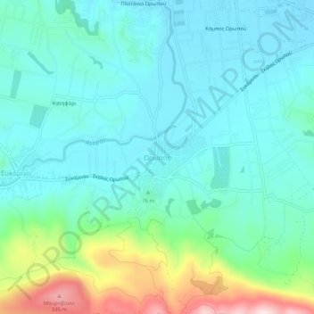
Name: Ωρωπός topographic map, elevation, terrain.
Average elevation: 83 m
Minimum elevation: 2 m
Maximum elevation: 368 m
Other topographic maps
Click on a map to view its topography, its elevation and its terrain.
Municipality of Oropos
Greece > Attica > Regional Unit of East Attica
Municipality of Oropos, Regional Unit of East Attica, Attica, Greece
Average elevation: 333 m
Kalamos
Greece > Attica > Regional Unit of East Attica
Kalamos, Municipality of Oropos, Regional Unit of East Attica, Attica, 190 17, Greece
Average elevation: 242 m