
Mount Saskatchewan topographic map
Interactive map
Click on the map to display elevation.
About this map
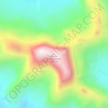
Name: Mount Saskatchewan topographic map, elevation, terrain.
Location: Mount Saskatchewan, Alberta, Canada (52.09995 -117.09315 52.10005 -117.09305)
Average elevation: 2,687 m
Minimum elevation: 2,327 m
Maximum elevation: 3,276 m
Other topographic maps
Click on a map to view its topography, its elevation and its terrain.
Sunset Beach (summer village)
Sunset Beach (summer village), Alberta, Canada
Average elevation: 640 m
Rutherford
Canada > Alberta > Division No. 11 > Edmonton
Rutherford, Heritage Point, Heritage Valley, Edmonton, Division No. 11, Alberta, Canada
Average elevation: 692 m
Edith Lake
Canada > Alberta > Division No. 15 > Municipality of Jasper
Edith Lake, Municipality of Jasper, Division No. 15, Alberta, Canada
Average elevation: 1,051 m
George Peak
Canada > Alberta > Municipal District of Greenview
George Peak, Municipal District of Greenview, Alberta, Canada
Average elevation: 2,066 m
Municipal District of Bonnyville
Municipal District of Bonnyville, Alberta, Canada
Average elevation: 625 m
Beaverdam
Canada > Alberta > Municipal District of Bonnyville
Beaverdam, Municipal District of Bonnyville, Alberta, Canada
Average elevation: 567 m
Scona area
Hazeldean, Mill Creek South Area, Scona area, Edmonton, Alberta, Canada
Average elevation: 673 m
Jasper National Park
Jasper National Park, Alberta, T0E 1E0, Canada
Average elevation: 1,782 m
Angel Glacier
Angel Glacier, (Former) Path of the Glacier Loop Trail, Alberta, Canada
Average elevation: 2,361 m
Bon Accord
Canada > Alberta > Bon Accord
Bon Accord, Town of Bon Accord, Alberta, T0A 0K0, Canada
Average elevation: 690 m
Dome Glacier
Dome Glacier, Mount Andromeda South Ridge Route, Alberta, Canada
Average elevation: 2,618 m
Hector Glacier
Hector Glacier, Mount Hector Route, Alberta, Canada
Average elevation: 2,743 m
Wapta Icefield
Wapta Icefield, Wapta Icefields Routes, Columbia-Shuswap Regional District, Alberta, Canada
Average elevation: 2,646 m
Peyto Glacier
Peyto Glacier, Trapper Peak Route, Columbia-Shuswap Regional District, Alberta, Canada
Average elevation: 2,421 m
Waputik Icefield
Waputik Icefield, Wapta Traverse, Columbia-Shuswap Regional District, Alberta, Canada
Average elevation: 2,439 m
Mount Galatea
Mount Galatea, Kananaskis Improvement District, Alberta, Canada
Average elevation: 2,537 m
Crowfoot Glacier
Crowfoot Glacier, Crowfoot Mountain Approach Route, Alberta, Canada
Average elevation: 2,550 m
Mount Cline
Mount Cline, Clearwater County, Alberta, Canada
Average elevation: 2,698 m