
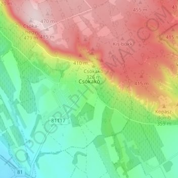
Csókakő topographic map
Interactive map
Click on the map to display elevation.
About this map
Name: Csókakő topographic map, elevation, terrain.
Average elevation: 297 m
Minimum elevation: 149 m
Maximum elevation: 486 m
Other topographic maps
Click on a map to view its topography, its elevation and its terrain.
Sárkeresztúr
Sárkeresztúr, Sárbogárdi járás, Fejér, Central Transdanubia, Transdanubia, 8125, Hungary
Average elevation: 110 m
Pusztaszabolcs
Pusztaszabolcs, Dunaújvárosi járás, Fejér, Central Transdanubia, Transdanubia, 2490, Hungary
Average elevation: 121 m
Dunaújváros
Dunaújváros, Dunaújvárosi járás, Fejér, Central Transdanubia, Transdanubia, Hungary
Average elevation: 119 m
Székesfehérvár
Székesfehérvár, Székesfehérvári járás, Fejér, Central Transdanubia, Transdanubia, Hungary
Average elevation: 133 m
Nagyegyháza
Hungary > Fejér > Óbarok > Nagyegyháza
Nagyegyháza, Óbarok, Bicskei járás, Fejér, Central Transdanubia, Transdanubia, 2063, Hungary
Average elevation: 231 m
Székesfehérvár
Hungary > Fejér > Székesfehérvár
Székesfehérvár, Székesfehérvári járás, Fejér, Central Transdanubia, Transdanubia, 8000, Hungary
Average elevation: 150 m