
Donauwörth topographic map
Interactive map
Click on the map to display elevation.
About this map
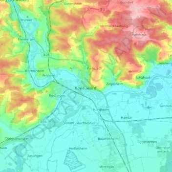
Name: Donauwörth topographic map, elevation, terrain.
Location: Donauwörth, Landkreis Donau-Ries, Beieren, 86609, Duitsland (48.67555 10.66884 48.76341 10.86788)
Average elevation: 443 m
Minimum elevation: 394 m
Maximum elevation: 561 m
Other topographic maps
Click on a map to view its topography, its elevation and its terrain.
Harburg (Schwaben)
Duitsland > Beieren > Landkreis Donau-Ries
Harburg (Schwaben), Landkreis Donau-Ries, Beieren, 86655, Duitsland
Average elevation: 473 m
Wallerstein
Duitsland > Beieren > Landkreis Donau-Ries
Wallerstein, Wallerstein (VGem), Landkreis Donau-Ries, Beieren, 86757, Duitsland
Average elevation: 448 m
Rain
Duitsland > Beieren > Landkreis Donau-Ries
Rain, Rain (Schwaben), Landkreis Donau-Ries, Beieren, 86641, Duitsland
Average elevation: 414 m
Nördlingen
Duitsland > Beieren > Landkreis Donau-Ries
Nördlingen, Landkreis Donau-Ries, Beieren, Duitsland
Average elevation: 453 m