
Thank you for supporting this site ❤️
Make a donation
Make a donation
Glenridding Dodd topographic map
Click on the map to display elevation.
Thank you for supporting this site ❤️
Make a donation
Make a donation
Glenridding Dodd
Glenridding Dodd (the rounded hill above Glenridding) is a small fell in the English Lake District, at the end of a ridge descending from the Helvellyn range in the Eastern Fells. It stands above the village of Glenridding and on the western shore of Ullswater. Although small and not of great elevation, its top is a fine viewpoint for Ullswater and for the fells clustered round the valleys above Patterdale.
Thank you for supporting this site ❤️
Make a donation
Make a donation
About this map
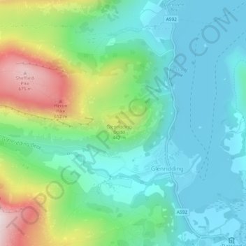
Name: Glenridding Dodd topographic map, elevation, terrain.
Average elevation: 298 m
Minimum elevation: 143 m
Maximum elevation: 698 m
Thank you for supporting this site ❤️
Make a donation
Make a donation