
Thank you for supporting this site ❤️
Make a donation
Make a donation
New Baltimore topographic map
Click on the map to display elevation.
Thank you for supporting this site ❤️
Make a donation
Make a donation
About this map
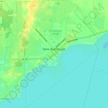
Name: New Baltimore topographic map, elevation, terrain.
Location: New Baltimore, Macomb County, Michigan, United States (42.65115 -82.76300 42.70606 -82.70597)
Average elevation: 178 m
Minimum elevation: 171 m
Maximum elevation: 192 m
Thank you for supporting this site ❤️
Make a donation
Make a donation
Other topographic maps
Click on a map to view its topography, its elevation and its terrain.
Anchor Bay Shores
United States > Michigan > Macomb County > Chesterfield Township
Average elevation: 176 m
Preston Corners
United States > Michigan > Macomb County > Shelby Charter Township
Average elevation: 198 m
Thank you for supporting this site ❤️
Make a donation
Make a donation
Shelby Charter Township
United States > Michigan > Macomb County > Shelby Charter Township
Average elevation: 205 m
Sterling Heights
United States > Michigan > Macomb County > Sterling Heights > Sterling Heights
Average elevation: 205 m