
Duingen topographic map
Interactive map
Click on the map to display elevation.
About this map
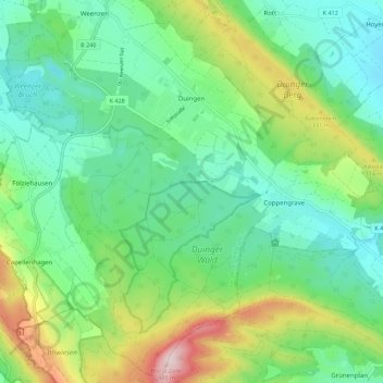
Name: Duingen topographic map, elevation, terrain.
Average elevation: 235 m
Minimum elevation: 134 m
Maximum elevation: 479 m
Other topographic maps
Click on a map to view its topography, its elevation and its terrain.
Limmer
Allemagne > Basse-Saxe > Hildesheim (arrondissement) > Alfeld (Leine) > Limmer
Limmer, Alfeld (Leine), Hildesheim (arrondissement), Basse-Saxe, 31061, Allemagne
Average elevation: 128 m