
Make a donation
Har Bental topographic map
Click on the map to display elevation.
Make a donation
Har Bental
Mount Bental (Arabic: جبل بنطل, جبل الغرام / ALA-LC: Jabal al-Gharam / "Mountain of Lust" "Jabal Bental"; Hebrew: הר בנטל, Har Bental, "Mount Bental" (lit. "Son of Dew") is a dormant volcano in the North-Eastern part of the Golan Heights, It extends to an elevation of 1,171 meters above sea level.
Make a donation
About this map
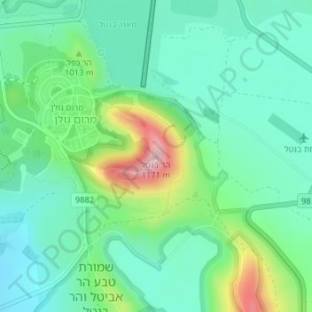
Name: Har Bental topographic map, elevation, terrain.
Average elevation: 975 m
Minimum elevation: 904 m
Maximum elevation: 1,164 m
Make a donation
Other topographic maps
Click on a map to view its topography, its elevation and its terrain.
Nimrod Fortress National Park
Israel > North District > Golan Regional Council
Average elevation: 674 m
El Rom
Israel > North District > Golan Regional Council
The kibbutz is about ten kilometers (6.2 mi) south of Mount Hermon, at an elevation of 1,050–1,070 meters (3,440–3,510 ft) above sea level. El Rom and the nearby moshav Odem are the two Jewish settlements in Israel with the highest elevation after Nimrod.
Average elevation: 1,062 m
Make a donation
Yehudia - Brechat HaMeshushim Site Nature Reserve
Israel > North District > Golan Regional Council
Average elevation: 91 m
Make a donation
Avnay Eitan
Israel > North District > Golan Regional Council
Avnei Eitan (Hebrew: אַבְנֵי אֵיתָן) is an Israeli settlement organized as a moshav in the southern Golan Heights, located at an elevation of 385 meters (1,263 ft) above sea level. Located to the east of the Sea of Galilee, it falls under the municipal jurisdiction of Golan Regional Council. In…
Average elevation: 384 m
Make a donation