
Thank you for supporting this site ❤️
Make a donation
Make a donation
Lac King topographic map
Click on the map to display elevation.
Thank you for supporting this site ❤️
Make a donation
Make a donation
About this map
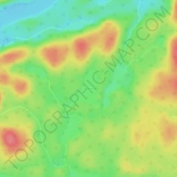
Name: Lac King topographic map, elevation, terrain.
Average elevation: 406 m
Minimum elevation: 371 m
Maximum elevation: 446 m
Thank you for supporting this site ❤️
Make a donation
Make a donation
Other topographic maps
Click on a map to view its topography, its elevation and its terrain.
Rivière des Outaouais
Canada > Québec > La Vallée-de-la-Gatineau > Lac-Moselle
Average elevation: 427 m
Thank you for supporting this site ❤️
Make a donation
Make a donation