
Thank you for supporting this site ❤️
Make a donation
Make a donation
Cherubei topographic map
Click on the map to display elevation.
Thank you for supporting this site ❤️
Make a donation
Make a donation
About this map
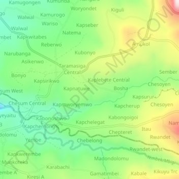
Name: Cherubei topographic map, elevation, terrain.
Location: Cherubei, Kapchorwa, Eastern Region, Uganda (1.29545 34.32375 1.33545 34.36375)
Average elevation: 1,461 m
Minimum elevation: 1,245 m
Maximum elevation: 1,809 m
Thank you for supporting this site ❤️
Make a donation
Make a donation