
Thank you for supporting this site ❤️
Make a donation
Make a donation
Le Castillon topographic map
Click on the map to display elevation.
Thank you for supporting this site ❤️
Make a donation
Make a donation
About this map
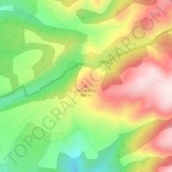
Name: Le Castillon topographic map, elevation, terrain.
Average elevation: 885 m
Minimum elevation: 697 m
Maximum elevation: 1,080 m
Thank you for supporting this site ❤️
Make a donation
Make a donation
Other topographic maps
Click on a map to view its topography, its elevation and its terrain.
Décollage du Mont Denier
France > Provence-Alpes-Côte d'Azur > Alpes-de-Haute-Provence > Moustiers-Sainte-Marie
Average elevation: 1,284 m