
Thank you for supporting this site ❤️
Make a donation
Make a donation
Naggl topographic map
Click on the map to display elevation.
Thank you for supporting this site ❤️
Make a donation
Make a donation
About this map
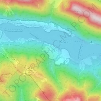
Name: Naggl topographic map, elevation, terrain.
Average elevation: 1,164 m
Minimum elevation: 920 m
Maximum elevation: 1,639 m
Thank you for supporting this site ❤️
Make a donation
Make a donation
Other topographic maps
Click on a map to view its topography, its elevation and its terrain.
Weißensee
Österreich > Kärnten > Bezirk Spittal an der Drau > Weißensee > Techendorf
Average elevation: 1,202 m