
Thank you for supporting this site ❤️
Make a donation
Make a donation
Evanger topographic map
Click on the map to display elevation.
Thank you for supporting this site ❤️
Make a donation
Make a donation
About this map
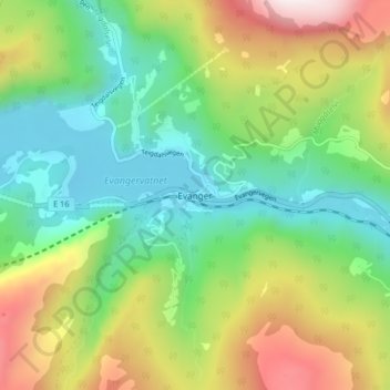
Name: Evanger topographic map, elevation, terrain.
Location: Evanger, Voss, Вестланн, 5707, Норвегия (60.62722 6.09216 60.66722 6.13216)
Average elevation: 308 m
Minimum elevation: 4 m
Maximum elevation: 867 m
Thank you for supporting this site ❤️
Make a donation
Make a donation
Other topographic maps
Click on a map to view its topography, its elevation and its terrain.