
Thank you for supporting this site ❤️
Make a donation
Make a donation
Rawaheng topographic map
Click on the map to display elevation.
Thank you for supporting this site ❤️
Make a donation
Make a donation
About this map
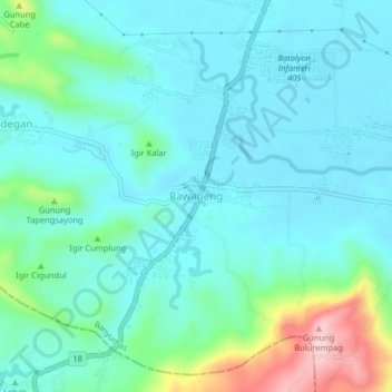
Name: Rawaheng topographic map, elevation, terrain.
Location: Rawaheng, Banyumas, Central Java, Java, 53252, Indonesia (-7.56171 109.02682 -7.52171 109.06682)
Average elevation: 65 m
Minimum elevation: 18 m
Maximum elevation: 254 m
Thank you for supporting this site ❤️
Make a donation
Make a donation
Other topographic maps
Click on a map to view its topography, its elevation and its terrain.