
Make a donation
Belo Horizonte topographic map
Click on the map to display elevation.
Make a donation
Belo Horizonte
In 1893, due to the climatic and topographic conditions, Curral Del Rey was selected by Minas Gerais governor Afonso Pena among other cities as the location for the new economic and cultural center of the state, under the new name of Cidade de Minas, or City of Minas.
Make a donation
About this map
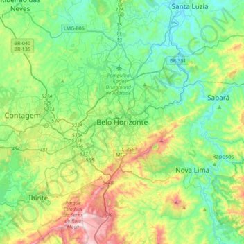
Name: Belo Horizonte topographic map, elevation, terrain.
Average elevation: 904 m
Minimum elevation: 675 m
Maximum elevation: 1,508 m
Make a donation
Other topographic maps
Click on a map to view its topography, its elevation and its terrain.
Betim
Brazil > Minas Gerais > Região Metropolitana de Belo Horizonte
Betim is located on the southwest of Belo Horizonte IGR, with Rio Paraopeba flowing through its south. Its average elevation is 830 meters above the sea level.
Average elevation: 829 m
Belo Horizonte
Brazil > Minas Gerais > Região Metropolitana de Belo Horizonte
In 1893 due to the climatic and topographic conditions, Curral Del Rey was selected by Minas Gerais governor Afonso Pena among other cities as the location for the new economic and cultural center of the state, under the new name of Cidade de Minas, or City of Minas.
Average elevation: 895 m
Make a donation
Brumadinho
Brazil > Minas Gerais > Região Metropolitana de Belo Horizonte
Brumadinho (Brazilian Portuguese: [bɾumaˈdʒiɲu]) is a Brazilian municipality in the state of Minas Gerais. The city belongs to the Belo Horizonte metropolitan mesoregion and to the microregion of Belo Horizonte. Brumadinho is at an altitude of 880 m. In 2020 the population was 40,666. The municipality is…
Average elevation: 889 m
Contagem
Brazil > Minas Gerais > Região Metropolitana de Belo Horizonte
The city belongs to the metropolitan mesoregion and to the microregion of Belo Horizonte, has a territorial extension of 195.2 square kilometres (75.4 square miles), and borders the municipalities of Ribeirão das Neves, Esmeraldas, Betim, Ibirité and Belo Horizonte. The elevation of the city hall is 939…
Average elevation: 887 m
Make a donation
Parque Industrial
Brazil > Minas Gerais > Região Metropolitana de Belo Horizonte > Contagem
Average elevation: 942 m
Jardim Teresópolis
Brazil > Minas Gerais > Região Metropolitana de Belo Horizonte > Betim
Average elevation: 896 m
Make a donation
Lagoa dos Ingleses
Brazil > Minas Gerais > Região Metropolitana de Belo Horizonte > Nova Lima
Average elevation: 1,335 m
Contagem
Brazil > Minas Gerais > Região Metropolitana de Belo Horizonte
The city belongs to the metropolitan mesoregion and to the microregion of Belo Horizonte, has a territorial extension of 195.2 square kilometres (75.4 square miles), and borders the municipalities of Ribeirão das Neves, Esmeraldas, Betim, Ibirité and Belo Horizonte. The elevation of the city hall is 939…
Average elevation: 887 m
Taquaraçu de Minas
Brazil > Minas Gerais > Região Metropolitana de Belo Horizonte
Average elevation: 874 m
Make a donation
Nova Contagem
Brazil > Minas Gerais > Região Metropolitana de Belo Horizonte > Contagem
Average elevation: 907 m
Belo Horizonte
Brazil > Minas Gerais > Região Metropolitana de Belo Horizonte
In 1893 due to the climatic and topographic conditions, Curral Del Rey was selected by Minas Gerais governor Afonso Pena among other cities as the location for the new economic and cultural center of the state, under the new name of Cidade de Minas, or City of Minas.
Average elevation: 895 m
Make a donation
Belo Horizonte
Brazil > Minas Gerais > Região Metropolitana de Belo Horizonte
In 1893 due to the climatic and topographic conditions, Curral Del Rey was selected by Minas Gerais governor Afonso Pena among other cities as the location for the new economic and cultural center of the state, under the new name of Cidade de Minas, or City of Minas.
Average elevation: 895 m
Vila Beneves
Brazil > Minas Gerais > Região Metropolitana de Belo Horizonte > Contagem
Average elevation: 897 m
Brumadinho
Brazil > Minas Gerais > Região Metropolitana de Belo Horizonte
Brumadinho (Brazilian Portuguese: [bɾumaˈdʒiɲu]) is a Brazilian municipality in the state of Minas Gerais. The city belongs to the Belo Horizonte metropolitan mesoregion and to the microregion of Belo Horizonte. Brumadinho is at an altitude of 880 m. In 2020 the population was 40,666. The municipality is…
Average elevation: 889 m
Belo Horizonte
Brazil > Minas Gerais > Região Metropolitana de Belo Horizonte
In 1893, due to the climatic and topographic conditions, Curral Del Rey was selected by Minas Gerais governor Afonso Pena among other cities as the location for the new economic and cultural center of the state, under the new name of Cidade de Minas, or City of Minas.
Average elevation: 895 m
Make a donation
Belo Horizonte
Brazil > Minas Gerais > Região Metropolitana de Belo Horizonte
In 1893, due to the climatic and topographic conditions, Curral Del Rey was selected by Minas Gerais governor Afonso Pena among other cities as the location for the new economic and cultural center of the state, under the new name of Cidade de Minas, or City of Minas.
Average elevation: 895 m
Make a donation
Gameleira
Brazil > Minas Gerais > Região Metropolitana de Belo Horizonte > Belo Horizonte
Average elevation: 892 m
Make a donation
Centro de Arte Contemporânea Inhotim
Brazil > Minas Gerais > Região Metropolitana de Belo Horizonte > Brumadinho
Average elevation: 795 m