
Thank you for supporting this site ❤️
Make a donation
Make a donation
Pazardzhik topographic map
Click on the map to display elevation.
Thank you for supporting this site ❤️
Make a donation
Make a donation
Pazardzhik
Pazardzhik is one of the few cities with a flat topography without any elevations. The average elevation is 205 metres (673 ft) and covers the entire area of the city. The only exception is a slight elevation change in the riverbed of the Maritsa.
Thank you for supporting this site ❤️
Make a donation
Make a donation
About this map
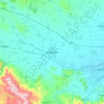
Name: Pazardzhik topographic map, elevation, terrain.
Location: Pazardzhik, Pazardzik, Pazardzhik, 4400, Bulgaria (42.02845 24.17190 42.34845 24.49190)
Average elevation: 337 m
Minimum elevation: 178 m
Maximum elevation: 1,472 m
Thank you for supporting this site ❤️
Make a donation
Make a donation