
Thank you for supporting this site ❤️
Make a donation
Make a donation
Eastern Division topographic map
Click on the map to display elevation.
Thank you for supporting this site ❤️
Make a donation
Make a donation
About this map
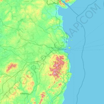
Name: Eastern Division topographic map, elevation, terrain.
Location: Eastern Division, Ireland (52.48475 -7.18532 54.11395 -5.99450)
Average elevation: 72 m
Minimum elevation: 0 m
Maximum elevation: 872 m
Thank you for supporting this site ❤️
Make a donation
Make a donation
Other topographic maps
Click on a map to view its topography, its elevation and its terrain.