
Thank you for supporting this site ❤️
Make a donation
Make a donation
Valparaiso Region topographic map
Click on the map to display elevation.
Thank you for supporting this site ❤️
Make a donation
Make a donation
About this map
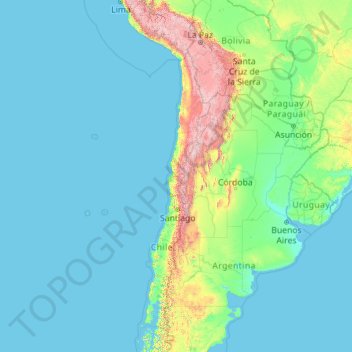
Name: Valparaiso Region topographic map, elevation, terrain.
Location: Valparaiso Region, Chile (-33.95619 -109.45488 -26.28623 -69.98916)
Average elevation: 376 m
Minimum elevation: -1 m
Maximum elevation: 6,527 m
Thank you for supporting this site ❤️
Make a donation
Make a donation
Other topographic maps
Click on a map to view its topography, its elevation and its terrain.
Tupungato
Chile > Santiago Metropolitan Region > Provincia de Cordillera > San José de Maipo
Average elevation: 6,003 m
Villa Cerro Castillo
Chile > Aysén Region > Provincia de General Carrera > Río Ibáñez
Average elevation: 379 m