
Poole Keynes topographic map
Interactive map
Click on the map to display elevation.
About this map
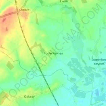
Name: Poole Keynes topographic map, elevation, terrain.
Average elevation: 99 m
Minimum elevation: 83 m
Maximum elevation: 128 m
Other topographic maps
Click on a map to view its topography, its elevation and its terrain.
Cirencester
Reino Unido > Inglaterra > Gloucestershire > Cotswold > Chesterton
Cirencester, Chesterton, Cotswold, Gloucestershire, Inglaterra, Reino Unido
Average elevation: 128 m
Kempsford
Reino Unido > Inglaterra > Gloucestershire > Cotswold
Kempsford, Cotswold, Gloucestershire, Inglaterra, GL7 4EQ, Reino Unido
Average elevation: 78 m
Somerford Keynes
Reino Unido > Inglaterra > Gloucestershire > Cotswold
Somerford Keynes, Cotswold, Gloucestershire, Inglaterra, GL7 6DR, Reino Unido
Average elevation: 91 m