
Thank you for supporting this site ❤️
Make a donation
Make a donation
7640 topographic map
Click on the map to display elevation.
Thank you for supporting this site ❤️
Make a donation
Make a donation
About this map
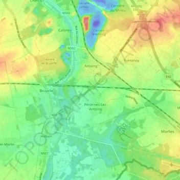
Name: 7640 topographic map, elevation, terrain.
Average elevation: 32 m
Minimum elevation: -106 m
Maximum elevation: 83 m
Thank you for supporting this site ❤️
Make a donation
Make a donation
Other topographic maps
Click on a map to view its topography, its elevation and its terrain.
Grand Large de Péronnes
Belgique > Hainaut > Tournai-Mouscron > Péronnes-Lez-Antoing
Average elevation: 22 m