
Thank you for supporting this site ❤️
Make a donation
Make a donation
Montpellier topographic map
Click on the map to display elevation.
Thank you for supporting this site ❤️
Make a donation
Make a donation
About this map
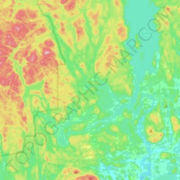
Name: Montpellier topographic map, elevation, terrain.
Location: Montpellier, Papineau, Outaouais, Quebec, J0V 1M0, Canada (45.81402 -75.39467 45.97357 -75.11892)
Average elevation: 273 m
Minimum elevation: 172 m
Maximum elevation: 510 m
Thank you for supporting this site ❤️
Make a donation
Make a donation
Other topographic maps
Click on a map to view its topography, its elevation and its terrain.
Thank you for supporting this site ❤️
Make a donation
Make a donation
Réserve écologique de la Forêt-la-Blanche
Canada > Quebec > Papineau > Mulgrave-et-Derry
Average elevation: 243 m