
Make a donation
Ahuy topographic map
Click on the map to display elevation.
Make a donation
Ahuy
The commune has an average altitude of 350m with the lowest point at the Suzon river [fr] in the east and highest point of 395m at the intersection of the Chemin des Vaches (CR21) and the Chemin du Bois de Vantoux (CR18).
Make a donation
About this map
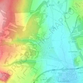
Name: Ahuy topographic map, elevation, terrain.
Average elevation: 312 m
Minimum elevation: 259 m
Maximum elevation: 401 m
Make a donation
Other topographic maps
Click on a map to view its topography, its elevation and its terrain.
Le Cailleret
France > Bourgogne – Franche-Comté > Côte-d'Or > Puligny-Montrachet
Average elevation: 276 m
Bierre en Morvan
France > Bourgogne – Franche-Comté > Côte-d'Or > La Roche-en-Brenil
Average elevation: 385 m
Mont Auxois
France > Bourgogne – Franche-Comté > Côte-d'Or > Alise-Sainte-Reine
Average elevation: 307 m
Make a donation
Au Faubourg
France > Bourgogne – Franche-Comté > Côte-d'Or > Flavigny-sur-Ozerain
Average elevation: 379 m
Auvillard
France > Bourgogne – Franche-Comté > Côte-d'Or > Saint-Victor-sur-Ouche
Average elevation: 438 m