
Make a donation
Jensen Beach topographic map
Click on the map to display elevation.
Make a donation
Jensen Beach
The Skyline Drive area includes some of the highest points in the community, reaching an elevation of 70 feet (21 m) at one point.
Make a donation
About this map
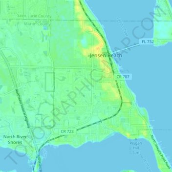
Name: Jensen Beach topographic map, elevation, terrain.
Location: Jensen Beach, Martin County, Florida, 34957, United States (27.21228 -80.28410 27.26385 -80.20981)
Average elevation: 5 m
Minimum elevation: -3 m
Maximum elevation: 21 m
Make a donation
Other topographic maps
Click on a map to view its topography, its elevation and its terrain.
Jensen Beach
United States > Florida > Martin County > Jensen Beach
The Skyline Drive area includes some of the highest points in the community, reaching an elevation of 70 feet (21 m) at one point.
Average elevation: 5 m
Make a donation
Make a donation
Jensen Beach
United States > Florida > Martin County > Jensen Beach
The Skyline Drive area includes some of the highest points in the community, reaching an elevation of 70 feet (21 m) at one point.
Average elevation: 5 m
Make a donation