
Thank you for supporting this site ❤️
Make a donation
Make a donation
Cuzco topographic map
Click on the map to display elevation.
Thank you for supporting this site ❤️
Make a donation
Make a donation
Cuzco
Cusco or Cuzco (Spanish: [ˈkusko]; Quechua: Qosqo or Qusqu, pronounced [ˈqɔsqɔ]) is a city in southeastern Peru, near the Sacred Valley of the Andes mountain range and the Huatanay river. It is the capital of the eponymous province and department. The city is the seventh most populous in Peru; in 2017, it had a population of 428,450. Its elevation is around 3,400 m (11,200 ft).
Thank you for supporting this site ❤️
Make a donation
Make a donation
About this map
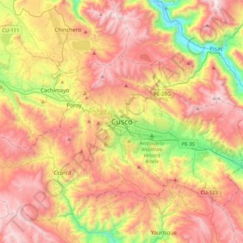
Name: Cuzco topographic map, elevation, terrain.
Average elevation: 3,790 m
Minimum elevation: 2,929 m
Maximum elevation: 4,576 m
Thank you for supporting this site ❤️
Make a donation
Make a donation