
Thank you for supporting this site ❤️
Make a donation
Make a donation
Burhanuddin topographic map
Click on the map to display elevation.
Thank you for supporting this site ❤️
Make a donation
Make a donation
About this map
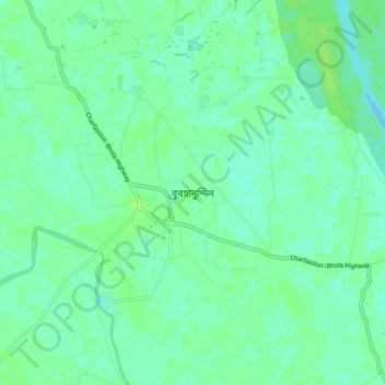
Name: Burhanuddin topographic map, elevation, terrain.
Average elevation: 4 m
Minimum elevation: 0 m
Maximum elevation: 8 m
Thank you for supporting this site ❤️
Make a donation
Make a donation
Other topographic maps
Click on a map to view its topography, its elevation and its terrain.
Pond of Reshot Ali house
Bangladesh > Barishal Division > Borhanuddin Subdistrict
Average elevation: 5 m
Pond Of Sofiq Maowlana
Bangladesh > Barishal Division > Borhanuddin Subdistrict
Average elevation: 4 m