
Thank you for supporting this site ❤️
Make a donation
Make a donation
La Ronge topographic map
Click on the map to display elevation.
Thank you for supporting this site ❤️
Make a donation
Make a donation
About this map
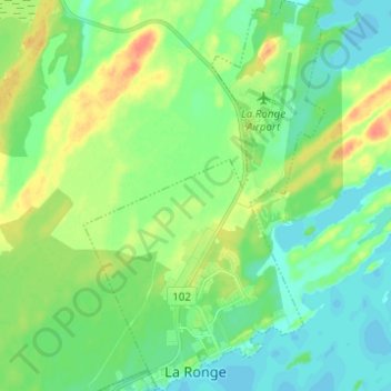
Name: La Ronge topographic map, elevation, terrain.
Location: La Ronge, Division No. 18, Saskatchewan, S0J 1L0, Canada (55.09706 -105.32526 55.16748 -105.24915)
Average elevation: 374 m
Minimum elevation: 360 m
Maximum elevation: 400 m
Thank you for supporting this site ❤️
Make a donation
Make a donation
Other topographic maps
Click on a map to view its topography, its elevation and its terrain.