
Thank you for supporting this site ❤️
Make a donation
Make a donation
Eau Claire topographic map
Click on the map to display elevation.
Thank you for supporting this site ❤️
Make a donation
Make a donation
About this map
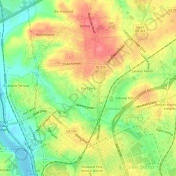
Name: Eau Claire topographic map, elevation, terrain.
Average elevation: 81 m
Minimum elevation: 41 m
Maximum elevation: 118 m
Thank you for supporting this site ❤️
Make a donation
Make a donation
Other topographic maps
Click on a map to view its topography, its elevation and its terrain.
Harbison State Forest
United States > South Carolina > Richland County > Columbia
Average elevation: 79 m