
Thank you for supporting this site ❤️
Make a donation
Make a donation
Boswil topographic map
Click on the map to display elevation.
Thank you for supporting this site ❤️
Make a donation
Make a donation
About this map
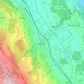
Name: Boswil topographic map, elevation, terrain.
Location: Boswil, Bezirk Muri, Aargau, 5623, Schweiz (47.27464 8.28365 47.32852 8.34093)
Average elevation: 516 m
Minimum elevation: 386 m
Maximum elevation: 793 m
Thank you for supporting this site ❤️
Make a donation
Make a donation
Other topographic maps
Click on a map to view its topography, its elevation and its terrain.