
Thank you for supporting this site ❤️
Make a donation
Make a donation
Alum Creek topographic map
Click on the map to display elevation.
Thank you for supporting this site ❤️
Make a donation
Make a donation
Alum Creek
Near 40°10′36″N 082°57′24″W / 40.17667°N 82.95667°W / 40.17667; -82.95667 (Alum Creek Lake) Elevation: 833 feet (254 m)
Thank you for supporting this site ❤️
Make a donation
Make a donation
About this map
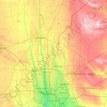
Name: Alum Creek topographic map, elevation, terrain.
Average elevation: 303 m
Minimum elevation: 185 m
Maximum elevation: 434 m
Thank you for supporting this site ❤️
Make a donation
Make a donation
Other topographic maps
Click on a map to view its topography, its elevation and its terrain.