
Thank you for supporting this site ❤️
Make a donation
Make a donation
Norwood topographic map
Click on the map to display elevation.
Thank you for supporting this site ❤️
Make a donation
Make a donation
About this map
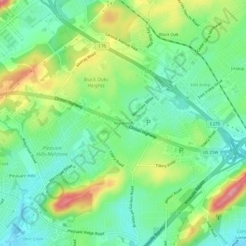
Name: Norwood topographic map, elevation, terrain.
Average elevation: 328 m
Minimum elevation: 289 m
Maximum elevation: 399 m
Thank you for supporting this site ❤️
Make a donation
Make a donation
Other topographic maps
Click on a map to view its topography, its elevation and its terrain.
Victor Ashe Park
United States > Tennessee > Knox County > Knoxville > Windsor Park
Average elevation: 314 m
Thank you for supporting this site ❤️
Make a donation
Make a donation