
Make a donation
Breuil-Cervinia topographic map
Click on the map to display elevation.
Make a donation
Breuil-Cervinia
The ski area is very large and guarantees good snow quality during the season, being at a high altitude (2,050 m to 3,500 m).
Make a donation
About this map
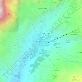
Name: Breuil-Cervinia topographic map, elevation, terrain.
Location: Breuil-Cervinia, Valtournenche, Aosta Valley, 11021, Italy (45.91560 7.61044 45.95560 7.65044)
Average elevation: 2,376 m
Minimum elevation: 1,914 m
Maximum elevation: 3,806 m
Make a donation
Other topographic maps
Click on a map to view its topography, its elevation and its terrain.
Courmayeur
At an elevation of 1,224 m (4,016 ft) above sea level, it is located at the foot of the southern side of Mont Blanc, at 4,810 m (15,781 ft) the highest point in the Alps and western Europe (see Seven Summits), and is crossed by the Dora Baltea (fr. Doire baltée) river.
Average elevation: 2,366 m
Make a donation
Gran Paradiso National Park
Italy > Aosta Valley > Torino
The park is located in the Graian Alps in the regions of Piedmont (in the Metropolitan City of Turin) and Aosta Valley in northwest Italy. It encompasses 703 square kilometres (174,000 acres) of alpine terrain. 10% of the park's surface area is wooded. 16.5% is used for agriculture and pasture, 24% is…
Average elevation: 2,135 m
Make a donation
Ghiacciaio di Indren
Italy > Aosta Valley > Vercelli > Gressoney-La-Trinité
Average elevation: 3,480 m
Make a donation
Gran Paradiso National Park
Italy > Aosta Valley > Turin
The park is located in the Graian Alps in the regions of Piedmont (in the Metropolitan City of Turin) and Aosta Valley in northwest Italy. It encompasses 703 square kilometres (174,000 acres) of alpine terrain. 10% of the park's surface area is wooded. 16.5% is used for agriculture and pasture, 24% is…
Average elevation: 2,135 m
Make a donation
Make a donation
Make a donation
Make a donation
Courmayeur
At an elevation of 1,224 m (4,016 ft) above sea level, it is located at the foot of the southern side of Mont Blanc, at 4,810 m (15,781 ft) the highest point in the Alps and western Europe (see Seven Summits), and is crossed by the Dora Baltea (fr. Doire baltée) river.
Average elevation: 2,366 m
Make a donation
Courmayeur
At an elevation of 1,224 m (4,016 ft) above sea level, it is located at the foot of the southern side of Mont Blanc, at 4,810 m (15,781 ft) the highest point in the Alps and western Europe (see Seven Summits), and is crossed by the Dora Baltea (fr. Doire baltée) river.
Average elevation: 2,366 m
Make a donation
Courmayeur
At an elevation of 1,224 m (4,016 ft) above sea level, it is located at the foot of the southern side of Mont Blanc, at 4,810 m (15,781 ft) the highest point in the Alps and western Europe (see Seven Summits), and is crossed by the Dora Baltea (fr. Doire baltée) river.
Average elevation: 2,366 m
Make a donation
Make a donation