
Thank you for supporting this site ❤️
Make a donation
Make a donation
Dongarwadi topographic map
Click on the map to display elevation.
Thank you for supporting this site ❤️
Make a donation
Make a donation
About this map
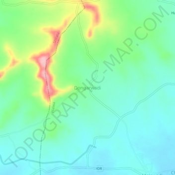
Name: Dongarwadi topographic map, elevation, terrain.
Location: Dongarwadi, Walwa, Sangli District, Maharashtra, 415401, India (16.91428 74.15754 16.95428 74.19754)
Average elevation: 603 m
Minimum elevation: 560 m
Maximum elevation: 717 m
Thank you for supporting this site ❤️
Make a donation
Make a donation
Other topographic maps
Click on a map to view its topography, its elevation and its terrain.