
Thank you for supporting this site ❤️
Make a donation
Make a donation
Le Logis Neuf topographic map
Click on the map to display elevation.
Thank you for supporting this site ❤️
Make a donation
Make a donation
About this map
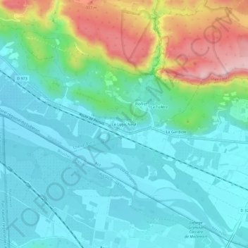
Name: Le Logis Neuf topographic map, elevation, terrain.
Average elevation: 166 m
Minimum elevation: 94 m
Maximum elevation: 381 m
Thank you for supporting this site ❤️
Make a donation
Make a donation
Other topographic maps
Click on a map to view its topography, its elevation and its terrain.
Réserve biologique dirigée du Petit Luberon
France > Provence-Alpes-Côte d'Azur > Vaucluse > Cheval-Blanc
Average elevation: 348 m