
Bustarviejo topographic map
Interactive map
Click on the map to display elevation.
About this map
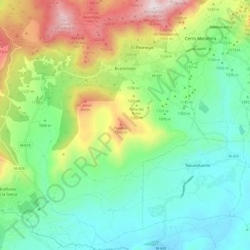
Name: Bustarviejo topographic map, elevation, terrain.
Average elevation: 1,153 m
Minimum elevation: 835 m
Maximum elevation: 1,823 m
Other topographic maps
Click on a map to view its topography, its elevation and its terrain.
La Pesquera - El Pornoso
Espanha > Comunidade de Madrid > Sierra Norte > Bustarviejo > La Pesquera - El Pornoso
La Pesquera - El Pornoso, Bustarviejo, Sierra Norte, Comunidade de Madrid, 28720, Espanha
Average elevation: 1,258 m