
Make a donation
Albertville topographic map
Click on the map to display elevation.
Make a donation
Albertville
Albertville is situated on the river Arly, close to the confluence with the river Isère. Its altitude ranges from 345 to 2,037 metres (1,132 to 6,683 ft). Nearby mountains include: Belle Étoile, Dent de Cons, Négresse, Roche Pourrie, Mirantin, Pointe de la Grande Journée, Chaîne du Grand Arc. Nearby mountain ranges include the Bauges, the Beaufortain and the beginning of the Vanoise.
Make a donation
About this map
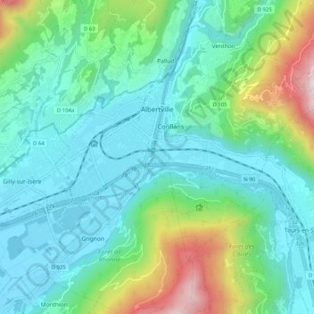
Name: Albertville topographic map, elevation, terrain.
Average elevation: 595 m
Minimum elevation: 313 m
Maximum elevation: 1,557 m
Make a donation
Other topographic maps
Click on a map to view its topography, its elevation and its terrain.
La Toussuire
France > Auvergne-Rhône-Alpes > Savoy > Fontcouverte-la-Toussuire
Average elevation: 1,710 m
Barrage de Roselend
France > Auvergne-Rhône-Alpes > Savoy > Beaufort
The dam has a maximum height of 150 m (492 ft) and a length of 804 m (2,638 ft). It is 3 m (10 ft) wide at its crest and 22 m (72 ft) wide at its base. The dam has a structural volume of 945,000 m3 (1,236,013 cu yd). Its reservoir, Lac de Roselend, can store 187,000,000 m3 (151,603 acre⋅ft) of water and has…
Average elevation: 1,598 m
Les Granges
France > Auvergne-Rhône-Alpes > Savoy > Saint-Martin-de-Belleville
Average elevation: 1,803 m
Make a donation
Saint-Jean-de-Maurienne
France > Auvergne-Rhône-Alpes > Savoy > Saint-Jean-de-Maurienne > Saint-Jean-de-Maurienne
Average elevation: 1,089 m
Val Thorens
France > Auvergne-Rhône-Alpes > Savoy
Val Thorens ([val tɔʁɑ̃]) is a ski town in the Tarentaise Valley in the French Alps at an altitude of 2,300 m (7,500 ft). It is located in the commune of Saint-Martin-de-Belleville in the Savoie department. The resort forms part of the Les Trois Vallées ski area which, with over 600 km of slopes, is one…
Average elevation: 2,516 m
Make a donation
Plagne Villages
France > Auvergne-Rhône-Alpes > Savoy > La Plagne-Tarentaise
Average elevation: 2,104 m
Lac du Mont-Cenis
France > Auvergne-Rhône-Alpes > Savoy > Val-Cenis
Mont-Cenis Lake is a lake located in the Mont-Cenis massif at an altitude of 1,974 meters (6,476 ft) in the municipality of Val-Cenis in France. It is situated at the top of the Cenise valley, on the Italian side of the Mont-Cenis pass, the most frequented passage on the Lyon-Turin-Milan axis during the Middle…
Average elevation: 2,096 m
Col de l'Iseran
France > Auvergne-Rhône-Alpes > Savoy > Bonneval-sur-Arc
On both sides of the Col de l'Iseran, mountain pass cycling milestones mark the distance to the summit, the current altitude, and the average slope in the following kilometre.
Average elevation: 2,779 m
Make a donation
Val Thorens
France > Auvergne-Rhône-Alpes > Savoy
Val Thorens ([val tɔʁɑ̃]) is a ski town in the Tarentaise Valley in the French Alps at an altitude of 2,300 m (7,500 ft). It is located in the commune of Saint-Martin-de-Belleville in the Savoie department. The resort forms part of the Les Trois Vallées ski area which, with over 600 km of slopes, is one…
Average elevation: 2,516 m
Glacier de la Grande Casse
France > Auvergne-Rhône-Alpes > Savoy > Pralognan-la-Vanoise
Average elevation: 2,896 m
Les Ménuires
France > Auvergne-Rhône-Alpes > Savoy
The resort was founded in 1964 and has an altitude range of 1,850 m (6,070 ft).
Average elevation: 2,063 m
Make a donation
Val Thorens
France > Auvergne-Rhône-Alpes > Savoy
Val Thorens ([val tɔʁɑ̃]) is a ski town in the Tarentaise Valley in the French Alps at an altitude of 2,300 m (7,500 ft). It is located in the commune of Saint-Martin-de-Belleville in the Savoie department. The resort forms part of the Les Trois Vallées ski area which, with over 600 km of slopes, is one…
Average elevation: 2,516 m
Make a donation
Villard-Bernon
France > Auvergne-Rhône-Alpes > Savoy > Saint-Michel-de-Maurienne
Average elevation: 1,155 m
Make a donation
Montrigon
France > Auvergne-Rhône-Alpes > Savoy > Bourg-Saint-Maurice > Arc 1600
Average elevation: 1,096 m
Make a donation
Make a donation
Le Chapet
France > Auvergne-Rhône-Alpes > Savoy > La Giettaz > La Giettaz-en-Aravis
Average elevation: 1,397 m
Make a donation
Praranger
France > Auvergne-Rhône-Alpes > Savoy > Saint-Martin-de-Belleville
Average elevation: 1,867 m
Make a donation
Villarabout
France > Auvergne-Rhône-Alpes > Savoy > Saint-Martin-de-Belleville
Average elevation: 1,600 m
Make a donation
Make a donation
Make a donation
Make a donation
Make a donation
Les Fontanettes
France > Auvergne-Rhône-Alpes > Savoy > Saint-Martin-de-Belleville
Average elevation: 2,085 m
Le Chantel
France > Auvergne-Rhône-Alpes > Savoy > Bourg-Saint-Maurice > Arc 1800
Average elevation: 1,770 m
Make a donation
Puy Gris
France > Auvergne-Rhône-Alpes > Savoy > Saint-Colomban-des-Villards
Average elevation: 2,469 m
Make a donation
Le Grand Morétan
France > Auvergne-Rhône-Alpes > Savoy > Saint-Colomban-des-Villards
Average elevation: 2,307 m
Plagne Montalbert
France > Auvergne-Rhône-Alpes > Savoy > Aime-la-Plagne > Plagne Montalbert
Average elevation: 1,188 m
Make a donation
Le Grand Couloir
France > Auvergne-Rhône-Alpes > Savoy > Pralognan-la-Vanoise > Le Grand Couloir
Average elevation: 1,876 m
Make a donation
La Toussuire
France > Auvergne-Rhône-Alpes > Savoy > Fontcouverte-la-Toussuire
Average elevation: 1,710 m
Lac supérieur de Rhêmes-Golette
France > Auvergne-Rhône-Alpes > Savoy > Tignes
Average elevation: 3,047 m
Plagne Centre
France > Auvergne-Rhône-Alpes > Savoy > La Plagne-Tarentaise > Plagne Centre
Average elevation: 2,078 m
Make a donation
Make a donation