
Thank you for supporting this site ❤️
Make a donation
Make a donation
Ninane topographic map
Click on the map to display elevation.
Thank you for supporting this site ❤️
Make a donation
Make a donation
About this map
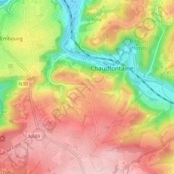
Name: Ninane topographic map, elevation, terrain.
Location: Ninane, Chaudfontaine, Liège, Wallonie, 4050, Belgique (50.56036 5.61812 50.60036 5.65812)
Average elevation: 190 m
Minimum elevation: 70 m
Maximum elevation: 288 m
Thank you for supporting this site ❤️
Make a donation
Make a donation
Other topographic maps
Click on a map to view its topography, its elevation and its terrain.
Thier des Critchions
Belgique > Liège > Liège > Chaudfontaine > Vaux-sous-Chèvremont > Mehagne
Average elevation: 115 m