
Make a donation
Ras Sudr topographic map
Click on the map to display elevation.
Make a donation
About this map
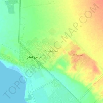
Name: Ras Sudr topographic map, elevation, terrain.
Location: Ras Sudr, South Sinai, 46612, Egypt (29.57694 32.68897 29.61485 32.75089)
Average elevation: 17 m
Minimum elevation: 0 m
Maximum elevation: 39 m
Make a donation
Other topographic maps
Click on a map to view its topography, its elevation and its terrain.
Make a donation
Make a donation
Make a donation
Saint Catherine
Köppen-Geiger climate classification system classifies the climate as desert (BWh). Saint Catherine has the coldest nights of any city in Egypt, and its humidity is very low. The highest mountain ranges in Egypt surround the town, with many smaller valleys leading from the basin to the mountains in all…
Average elevation: 1,472 m
Make a donation
Make a donation
Make a donation
Saint Catherine
Köppen-Geiger climate classification system classifies the climate as desert (BWh). Saint Catherine has the coldest nights of any city in Egypt, and its humidity is very low. The highest mountain ranges in Egypt surround the town, with many smaller valleys leading from the basin to the mountains in all…
Average elevation: 1,472 m
Make a donation
Make a donation