
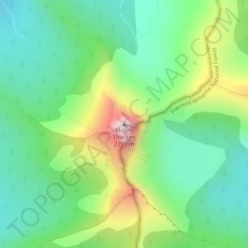
Mount Thielsen topographic map
Interactive map
Click on the map to display elevation.
About this map
Name: Mount Thielsen topographic map, elevation, terrain.
Location: Mount Thielsen, Douglas County, Oregon, USA (43.15282 -122.06661 43.15292 -122.06651)
Average elevation: 2,243 m
Minimum elevation: 2,005 m
Maximum elevation: 2,753 m
Other topographic maps
Click on a map to view its topography, its elevation and its terrain.
Cascade-Siskiyou National Monument
Cascade-Siskiyou National Monument, 40-3E-2, Lincoln, Jackson County, Oregon, USA
Average elevation: 1,213 m
Portland Downtown
Portland Downtown, Portland, Multnomah County, Oregon, USA
Average elevation: 50 m
Hart Mountain National Antelope Refuge
Hart Mountain National Antelope Refuge, Lake County, Oregon, USA
Average elevation: 1,594 m
Big Slide Mountain
Big Slide Mountain, Clackamas County, Oregon, USA
Average elevation: 1,363 m
McKenzie Bridge
USA > Oregon > McKenzie Bridge
McKenzie Bridge, Lane County, Oregon, 97413, USA
Average elevation: 521 m
Junction City
USA > Oregon > Junction City
Junction City, Lane County, Oregon, USA
Average elevation: 102 m
Milk Creek Glacier
Milk Creek Glacier, Pacific Crest Trail, Jefferson County, Oregon, USA
Average elevation: 2,508 m
Lost Creek Glacier
Lost Creek Glacier, South Sister Climber Trail #36, Deschutes County, Oregon, USA
Average elevation: 2,430 m
Sandy Glacier
Sandy Glacier, Yocum Ridge Trail #771, Clackamas County, Oregon, USA
Average elevation: 2,365 m
White River Glacier
White River Glacier, Mountaineer Trail #798, Clackamas County, Oregon, USA
Average elevation: 2,523 m
Benson Glacier
Benson Glacier, Eagle Cap Summit Trail, Union County, Oregon, USA
Average elevation: 2,489 m
Coalman Glacier
Coalman Glacier, Cooper Spur Trail #600B, Hood River County, Oregon, USA
Average elevation: 2,728 m
Ladd Glacier
Ladd Glacier, Barrett Spur, Hood River County, Oregon, USA
Average elevation: 2,305 m
Newton Clark Glacier
Newton Clark Glacier, Cooper Spur Trail #600B, Hood River County, Oregon, USA
Average elevation: 2,589 m
Mount Pisgah Arboretum
Mount Pisgah Arboretum, Seavey Way, Goshen, Lane County, Oregon, USA
Average elevation: 204 m
Glisan Glacier
Glisan Glacier, McNeil Point Trail #600M, Hood River County, Oregon, USA
Average elevation: 2,086 m
Eugene Glacier
Eugene Glacier, South Sister Climber Trail #36, Deschutes County, Oregon, USA
Average elevation: 2,487 m
Carver Glacier
Carver Glacier, South Sister Climber Trail #36, Deschutes County, Oregon, USA
Average elevation: 2,385 m
Crook Glacier
Crook Glacier, Broken Top NW Ridge route, Deschutes County, Oregon, USA
Average elevation: 2,347 m
Coe Glacier
Coe Glacier, Barrett Spur, Hood River County, Oregon, USA
Average elevation: 2,328 m
Zigzag Glacier
Zigzag Glacier, Mountaineer Trail #798, Clackamas County, Oregon, USA
Average elevation: 2,620 m
Upper Campbell Lake
Upper Campbell Lake, Hart Mountain Road, Lake County, Oregon, USA
Average elevation: 1,364 m
Skinner Butte
Skinner Butte, Eugene, Lane County, Oregon, 97401, USA
Average elevation: 130 m
Waldo Glacier
Waldo Glacier, Pacific Crest Trail, Jefferson County, Oregon, USA
Average elevation: 2,352 m
Whitewater Glacier
Whitewater Glacier, Pacific Crest Trail, Jefferson County, Oregon, USA
Average elevation: 2,460 m
Villard Glacier
Villard Glacier, climber's trail, Deschutes County, Oregon, USA
Average elevation: 2,448 m
Lathrop Glacier
Lathrop Glacier, Mt. Thielsen climber's trail, Douglas County, Oregon, USA
Average elevation: 2,235 m
Clark Glacier
Clark Glacier, South Sister Climber Trail #36, Deschutes County, Oregon, USA
Average elevation: 2,578 m
Renfrew Glacier
Renfrew Glacier, climber's trail, Deschutes County, Oregon, USA
Average elevation: 2,538 m
Prouty Glacier
Prouty Glacier, South Sister Climber Trail #36, Deschutes County, Oregon, USA
Average elevation: 2,589 m
Linn Glacier
Linn Glacier, Pacific Crest Trail, Deschutes County, Oregon, USA
Average elevation: 2,359 m
Hosford-Abernethy
Hosford-Abernethy, Portland, Multnomah County, Oregon, USA
Average elevation: 26 m
Reid Glacier
Reid Glacier, Yocum Ridge Trail #771, Clackamas County, Oregon, USA
Average elevation: 2,410 m
Bend Glacier
Bend Glacier, Broken Top NW Ridge route, Deschutes County, Oregon, USA
Average elevation: 2,350 m
Three Fingered Jack
Three Fingered Jack, Linn County, Oregon, USA
Average elevation: 1,881 m
Diller Glacier
Diller Glacier, climber's trail, Deschutes County, Oregon, USA
Average elevation: 2,416 m