
Make a donation
Tha Ton topographic map
Click on the map to display elevation.
Make a donation
Tha Ton
The village is overlooked by a hilltop Buddhist temple known as Wat Tha Ton. The temple complex includes four huge statues of the Buddha, two in typical Thai-style and two showing Chinese influence. One of these, the standing Buddha, is over 10 m tall. Overall, there are nine stations which include statues or shrines. The eighth station houses the monastery and various shrines. The ninth station is a 2 km walk along a paved footpath with elevation gain.
Make a donation
About this map
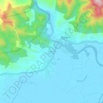
Name: Tha Ton topographic map, elevation, terrain.
Location: Tha Ton, Chiang Mai Province, Thailand (20.03772 99.33909 20.07772 99.37909)
Average elevation: 515 m
Minimum elevation: 442 m
Maximum elevation: 878 m
Make a donation
Other topographic maps
Click on a map to view its topography, its elevation and its terrain.