
Thornbury topographic map
Interactive map
Click on the map to display elevation.
About this map
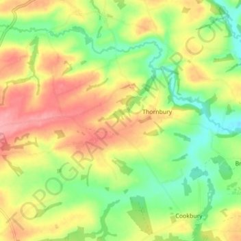
Name: Thornbury topographic map, elevation, terrain.
Location: Thornbury, Torridge District, Devon, England, United Kingdom (50.83550 -4.33167 50.86722 -4.25539)
Average elevation: 133 m
Minimum elevation: 86 m
Maximum elevation: 183 m
Other topographic maps
Click on a map to view its topography, its elevation and its terrain.
Watertown
United Kingdom > England > Devon > Torridge District > Northam
Watertown, Northam, Torridge District, Devon, England, EX39 1NF, United Kingdom
Average elevation: 16 m
Bideford
United Kingdom > England > Devon > Torridge District
Bideford, Torridge District, Devon, England, United Kingdom
Average elevation: 54 m