
Thank you for supporting this site ❤️
Make a donation
Make a donation
Fogo Island topographic map
Click on the map to display elevation.
Thank you for supporting this site ❤️
Make a donation
Make a donation
About this map
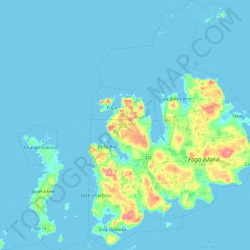
Name: Fogo Island topographic map, elevation, terrain.
Location: Fogo Island, Newfoundland, Newfoundland and Labrador, Canada (49.55722 -54.32496 49.83441 -53.98419)
Average elevation: 11 m
Minimum elevation: -1 m
Maximum elevation: 110 m
Thank you for supporting this site ❤️
Make a donation
Make a donation
Other topographic maps
Click on a map to view its topography, its elevation and its terrain.