
Thank you for supporting this site ❤️
Make a donation
Make a donation
Punkin Center topographic map
Click on the map to display elevation.
Thank you for supporting this site ❤️
Make a donation
Make a donation
About this map
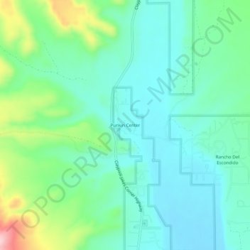
Name: Punkin Center topographic map, elevation, terrain.
Location: Punkin Center, Gila County, Arizona, 85553, United States (33.85227 -111.33319 33.89227 -111.29319)
Average elevation: 742 m
Minimum elevation: 690 m
Maximum elevation: 897 m
Thank you for supporting this site ❤️
Make a donation
Make a donation
Other topographic maps
Click on a map to view its topography, its elevation and its terrain.
Thank you for supporting this site ❤️
Make a donation
Make a donation
Star Valley
United States > Arizona > Gila County
According to the United States Census Bureau, the town has a total area of 36.1 square miles (93.6 km2), of which 0.01 square miles (0.02 km2), or 0.03%, is water. Star Valley sits at an elevation of 4,650 feet (1,420 m) and takes its name from the valley in which it is located, formed by Houston Creek, which…
Average elevation: 1,509 m
Thank you for supporting this site ❤️
Make a donation
Make a donation